- Engineering, Procurement and Construction
- Fabrication and Construction
- Coastal Engineering & Shore Protection
- Maritime Engineering Services
- Marine Transportation & Logistics
- Surveying and Geospatial Studies
- Environmental and Social Impact Assessment Studies
- Project Management and Consultancy Services
- Project Financing
Coastal Engineering
CDR Infrastructure can provide the following coastal engineering studies:
- Historical Coastline evolution studies.
- Wave and flow modelling studies to derive ambient and extreme (design) conditions.
- Integrated coastal zone management (ICZM) studies.
- Coastal protection and structural design studies inclusive of geotechnical analysis.
- Morphological impact studies.
Shore/Coastal Protection
Coastal protection works are often required adjacent to ports, coastal inlet/outlets, reclamation schemes and other man-made coastline interventions, or from the consequences of climate change. Coastal protection schemes are necessary to protect public and private properties from coastal erosion. Designs for these protection schemes may consist of (a combination of):
- Repetitive beach nourishment.
- Groynes, build from rocks or lighter structures (piles, geosynthetic elements).
- Reefs or breakwaters, low-crested or submerged reefs, attached or detached from the shoreline.
- Revetments consisting of rocks, concrete elements or seawalls
Each solution or a combination thereof has its own merits or disadvantages, to be customized and balanced for each project, based on the local situation, hydraulic conditions and client demands. Depending on the driving morphological forces, local coastal features and availability of material, the best solution is selected, and a design of the coastal protections scheme is made.
Dredging and Land Reclamation
The layout design of a land reclamation scheme is a combination of reclamation works, sand compaction, soil improvement and coastal protection of the reclaimed land. With growing economies and increasingly congested cities, land reclamation schemes provide high-value development areas at preferred locations. Land reclamation schemes are designed to withstand the largest storms and minimize flood risk for the reclamation area and the city behind it.
Port cities and coastal areas are increasing centers of economic activity that act as engines for national prosperity. Both in developed countries and economically emerging nations these areas are magnets for job seeking people. The enormous spatial challenge of accommodating everyone in terms of housing, employment, education, recreation, and transport can be solved by reclaiming new land.
Approach
CDR Infrastructure approaches land reclamation schemes in such a way that impact on the maritime environment is minimized, while proving new space to live, work and leisure. Land reclamation schemes are complex due to the social, economic, environmental, but moreover spatial impacts – shaping the coastline comes with responsibilities. We take on the responsibilities by:
- Setting up a broadly accepted and integrated design
- Using highly accurate met ocean and hydrodynamic modelling studies to quantify and minimize negative impacts
- Involvement of stakeholders in the earliest stage of the project
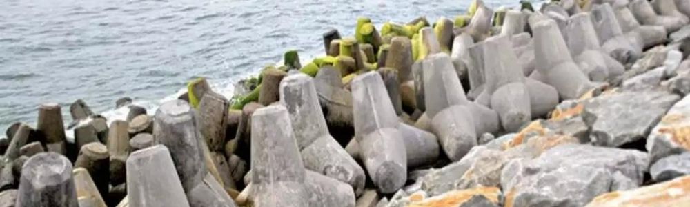
Breakwater, Revetment and Marine Structures
Structural Design
Optimization of structural marine designs aims to reduce construction costs, improve construction methodologies and find an optimum balance between costs, time, risk and maintenance. Thorough understanding of the environmental conditions, design factors and design formulae form the basis of the optimization process. Important aspect in the design of Hydraulic Structures is the combination of a theoretical correct design and practical design in reality. Any constraints of material and/or equipment should be investigated before design and taken into account. As construction costs form a large part of the total costs, highly practical construction is important in the design process where collaboration with the Contractor is very important.
Breakwaters often form a large part of the capital costs of port projects. Breakwaters and revetments furthermore provide the main protection of a port or land area against extreme wave conditions and are therefore essential to perform as anticipated.
The design of such structures should therefore be reliable and sufficiently stable, while the costs should be minimized as well. This requires proper and in-depth knowledge on the latest design techniques and extensive experience to obtain the most effective design.
We have in-depth knowledge of port breakwater and sea defence designs such as dynamically stable breakwaters (like berm breakwaters), concrete element breakwaters and rock breakwaters.
Approach
Design studies are always performed in accordance with the international design standards and the latest information and technologies.
Furthermore it is very important, not only to design according to the latest theories and standards to obtain a design ‘according to the books’, but to focus on the local hydraulic conditions (for construction), available construction material, and the expected equipment to be used.
A design should not only be functional on paper, it should also enable to construct properly and in accordance with the given criteria and tolerances under local circumstances. Therefore, a practical design which can be constructed in time and where the quality of construction can easily be obtained, is preferred over a design which only provides a low bill of quantities. Especially now, the construction costs, constructability, and time for construction become more and more important on the total costs and feasibility of a project.
Services
CDR Infrastructure provides the following services:
- Breakwater design:
We do not only look at the conventional designs, but also newly developed materials and construction techniques. Where considered efficient and operationally viable, we will consider alternatives with geo-synthetics, e.g. dedicated geotube and geocontainer systems to reduce core materials in breakwaters, groynes and revetments. - Breakwater optimization design:
Optimization of breakwater structures and marine structures to reduce the construction costs, improve construction methodologies and find an optimum balance between costs, time, risk and maintenance. - 2D and 3D physical model testing:
Breakwater and revetment designs are finally optimized and verified by means of 2D and 3D physical model testing.
CDR has performed several of such studies, successfully optimizing the design and increasing the functionality of the structure, and hence has experience with several laboratories in Europe and China to perform such physical model tests.
During the tests we focus on further optimization of designs and correct representation of the reality in the model. Focus on the constructability in reality starts already with the model testing, involvement of a contractor is therefore preferred to investigate the possibility to obtain same quality of construction in reality as in the model testing. - In particular CDR can assist in preparations of the model testing:
- Finding a suitable laboratory
- Supervising the model testing (including further optimization of the structure)
- Interpreting and presenting the results in reporting and PowerPoint presentations. The quality and reliability of the model testing is double-checked to obtain the required results
Cost optimization:
We advise clients by independent third party reviews on cost optimization by involvement of world-leading experts in breakwater design, highly experienced construction experts and senior works managers in combination with desk optimization studies.
Metocean Studies and Hydrodynamic Numerical Modelling
Data Services
Reliable hydraulic design conditions are crucial in every offshore, port and coastal development project. This begins with the acquisition, interpretation and validation of accurate offshore data, knowledge of the local climatology and the technology used to produce the data. Where available, all data are validated with measurement data from alternative sources such as buoys or satellites.
CDR Infrastructure maintains databases of global long-term wind and wave records as well as historical cyclone tracks which allows us to produce MetOcean reports for use for a first site selection and as critical input for numerical modelling studies. Available on-line data can furthermore be used to produce reliable wave fore-casts to optimize downtime during construction, increase accessibility of ports or determine the best time-slot for unloading in harsh conditions.
Operational, extreme as well as short term and forecasted wind and wave statistics can be provided for offshore locations which can be translated to nearshore by wave studies. In addition, we can develop site and project-specific marine forecast services.
CDR Infrastructure provides detailed and high quality meteorological and oceanic data (both archived data as well as forecast data) for use in offshore and coastal projects.
Wave Studies
Wave modelling studies are performed for the following purposes:
- Transform the offshore wave climate to their corresponding nearshore wave climates
- Perform wave disturbance and resonance studies in ports and harbours
- Provide input for sediment transport studies
- Derive wave loadings for marine structures, piles, pipelines etc.
Wave studies are performed from global scale to smaller, local scales; applying a wide range of state-of-the-art wave models. We operate both third generation spectral models (MIKE21-SW and SWAN) as well as time domain models (Boussinesq and non-hydrostatic, MIKE21-BW and SWASH).
Wave Disturbance
Wave conditions within ports and harbours often require the application of phase resolving models to properly take into account processes such as wave transmission, reflection and diffraction which are typically dominant in those areas. In certain circumstances, also long wave (infra-gravity wave) action and the port’s response to long waves is investigated as moored vessels are responsive to long wave frequencies. We have wide experience in studying wave phenomena typically dominant in port areas, making use of MIKE21-BW and SWASH. We perform detailed wave amplification analysis and wave resonance studies, as well as wave penetration of primary (sea and swell) waves.
Meteorological and Oceanographic (MetOcean) Studies
For the development and design of offshore and coastal structures, it is important to understand the mechanics of the sometimes harsh and challenging surroundings this new structure will be placed in. CDR maintains databases of global long-term wind and wave records as well as historical cyclone tracks which allows us to produce Metocean reports for use for a first site selection and as critical input for numerical modelling studies.
Operational, extreme as well as short term wind and wave statistics can be provided for offshore locations and later translated to nearshore by wave studies. In addition, we can develop site and project-specific marine forecast services.
Numerical Modeling Studies
Numerical modelling studies of waves and currents often form the basis for coastal, harbour and river engineering. Such models are applied to obtain or increase knowledge on the occurring water dynamics and hydraulic and morphological processes and to obtain design conditions for further engineering.
CDR Infrastructure has extensive hydrodynamic modelling experience and uses state-of-the-art modelling software including the MIKE21 suite, SWAN and Deltares software (D-flow, Delft3D, SOBEK).
Due to the experience obtained in numerous projects we can offer simple and straight-forward studies for preliminary designs up to extensive, in-depth numerical modelling of morphology, wave penetration into port basins and wave disturbance studies for final design of Port Projects.
Approach
Reliable hydraulic design conditions are crucial in every offshore, port and coastal development project. This begins with the acquisition, interpretation and validation of reliable offshore data, knowledge of the local climatology and the technology used to produce the data. Preferably such data is calibrated and verified by measurements, such services can be provided as well.
CDR Infrastructure provides detailed and high quality meteorological and oceanic data (both archived data as well as forecast data) for use in offshore and coastal projects. This can be gathered and used for preliminary design studies and later further enhanced and calibrated using measurements for final design studies, even further increasing the accuracy and reliability of the data and hence structural design.
Hydrodynamic modelling studies can be used to determine reliable hydraulic design conditions (waves, currents), assess morphological impacts, determine wave penetration into a port and to optimize coastal, land reclamation, dredging and riverine projects using a practical, straight forward and reliable approach.
Wave modelling studies are used to determined design wave conditions, either for conceptual, preliminary or final design, and to compute wave penetration into Ports or sheltered areas. Breakwater layouts and consequent wave penetration into Port areas is one of the most important design items for Ports as too high wave disturbance causes increased downtime. The (combined) effect of wind waves, swell waves and long waves (infra-gravity waves) from different directions should be properly taken into account to determine the wave disturbance and hence expected downtime at the berths. As the breakwater structures often form the main capital costs of a Port, optimization of the layout (breakwater length) may therefore be decisive for the feasibility of a project or winning the project as contractor. CDR Infrastructure in cooperation with partners have developed a quick, practical method to optimize (Port) Breakwater layouts using wave penetration modelling in an iterative process, enabling to optimize a Port design together with the Client in a single workshop session.
Services
CDR Infrastructure provides the following hydraulic and numerical modelling studies:
- MetOcean studies: high accuracy offshore wave- and wind data, including wave forecasting;
- Wave studies: nearshore wave statistics, reliable design wave conditions, wave penetration studies and wave disturbance studies (very long waves). Practical methods are available to optimize Port layouts using quick iterative wave penetration studies, being able to optimize the layout in a single workshop with the Client. In particular these and following wave studies can be performed:
- Transformation of an offshore wave climate to nearshore wave climates at required locations
- Wave penetration, wave disturbance and wave resonance studies in ports and harbours. Both practical and quick-scan studies as comprehensive (final design) studies including the whole range of wave conditions (wave heights, periods, directions, combination of conditions)
- Providing input for sediment transport studies
- Derive wave loadings for marine structures, piles, pipelines etc.
- Hydrodynamic modelling studies: (extreme) water levels, flow conditions and run-off in coastal areas, river system and urban areas.
- Morphological studies: coastal erosion studies, morphological impact studies, optimization of sand nourishment of land reclamations under changing year-round wave conditions.
Together with our partners we also provide site survey campaigns, viz. hydrographic, topographic and geotechnical survey campaigns to support the numerical modelling studies and provide for important local hydrodynamic and geotechnical data.