- Engineering, Procurement and Construction
- Fabrication and Construction
- Coastal Engineering & Shore Protection
- Maritime Engineering Services
- Marine Transportation & Logistics
- Surveying and Geospatial Studies
- Environmental and Social Impact Assessment Studies
- Project Management and Consultancy Services
- Project Financing
CDR Infrastructure and its specialist partners provide a wide range of surveying services, which include:
Land Perimeter Survey
We provide land survey service for your parcel of land to delineate it from other properties. This gives you an insight to the size and the survey plan that you get through the appropriate lodging with the appropriate office of the state government gives you ownership of the land. Our services relating to perimeter survey also include the following:
- Pre-land purchases advisory services
- Land in-dispute services
- Boundary encroachment
- Establishment of beacon
- Land subdivision
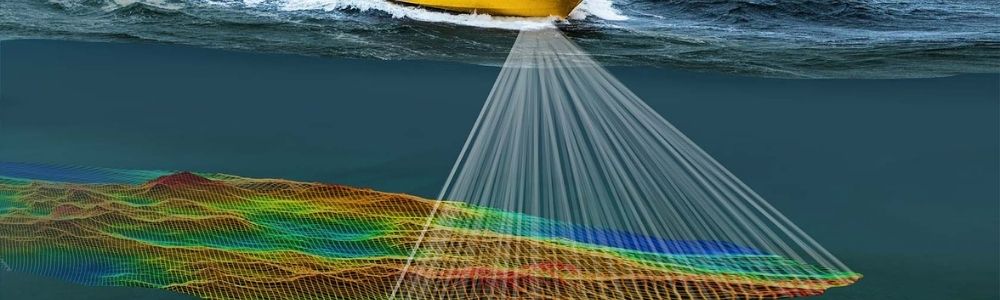
Hydrographic Survey
Our hydrographic survey service offers solutions to wide range of clients from governmental agencies to private organizations and multinational companies. We offer them timely and accurate data that suites their requirements. We provide the following services:
- Pre- and post-dredge volumetric calculations
- Volume calculations
- Waterfront development
- Port and harbor improvement projects
- Dock installations
- Environmental remediation
- Safety of navigation surveys
- Sedimentation
- Erosion sites
- Monitoring
- Underwater survey for steel pile corrosion, oil and gas structures
Engineering Survey
Our engineering survey services are suited to support infrastructure of different sizes and shades. From Right of Way (ROW) survey to topographic survey, As-built Survey, Drainage survey, Utility relocation Survey and others. These surveys provide data to infrastructure such as road, bridges, intelligent transportation design, flying structures, power lines and other overland projects.
We offer GIS and mapping solutions that is integrative and easy to adapt to many applications in the market. We also provide this information to ease your decision making and analysis across different industry.
Drone Survey
We also provide aerial mapping services, giving highly detailed, accurate sitemaps, made of a composite of hundreds of high-resolution photographs, in just a few hours with our high definitive drones. Also, we are capable of deploying underwater drones for marine works supervision.